
Litchfield COUNTY · Places & community
Sharon: the green, the valley and the crossing
A shop, two houses and thirteen bridge photographs connect Sharon’s village center with the industrial landscape of Webatuck Creek.
Historical focus · 1739–1996
LOOK CLOSER · OPEN ANY IMAGE
The story in photographs
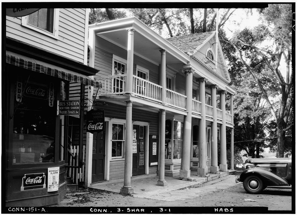
Sept. 15, 1940
Exterior, general view from south east
Exterior, general view from south east. Sept. 15, 1940.
Image credit & source
Stanley P. Mixon / Historic American Buildings Survey, Library of Congress
No known restrictions on photographs made by the U.S. Government. This selection excludes identified third-party photocopies.
Original source · Reuse termsSept. 15, 1940
Exterior, house from south east
Exterior, house from south east. Sept. 15, 1940.
Image credit & source
Stanley P. Mixon / Historic American Buildings Survey, Library of Congress
No known restrictions on photographs made by the U.S. Government. This selection excludes identified third-party photocopies.
Original source · Reuse termsSept. 15, 1940
Exterior, entrance porch and palladian window
Exterior, entrance porch and palladian window. Sept. 15, 1940.
Image credit & source
Stanley P. Mixon / Historic American Buildings Survey, Library of Congress
No known restrictions on photographs made by the U.S. Government. This selection excludes identified third-party photocopies.
Original source · Reuse termsJune 1996 — later survey photograph
View north, showing truss
View north, showing truss. June 1996 — later survey photograph.
Image credit & source
Robert Moore / ConnDOT; Historic American Engineering Record, Library of Congress
Library of Congress HABS/HAER collection rights advisory: no known restrictions on U.S. Government images; other images may be restricted. Survey photograph credited to Robert Moore / ConnDOT.
Original source · Reuse termsJune 1996 — later survey photograph
View north, showing south elevation
View north, showing south elevation. June 1996 — later survey photograph.
Image credit & source
Robert Moore / ConnDOT; Historic American Engineering Record, Library of Congress
Library of Congress HABS/HAER collection rights advisory: no known restrictions on U.S. Government images; other images may be restricted. Survey photograph credited to Robert Moore / ConnDOT.
Original source · Reuse termsJune 1996 — later survey photograph
View east, showing west approach
View east, showing west approach. June 1996 — later survey photograph.
Image credit & source
Robert Moore / ConnDOT; Historic American Engineering Record, Library of Congress
Library of Congress HABS/HAER collection rights advisory: no known restrictions on U.S. Government images; other images may be restricted. Survey photograph credited to Robert Moore / ConnDOT.
Original source · Reuse termsJune 1996 — later survey photograph
View southeast, showing east abutment at the southwest corner
View southeast, showing east abutment at the southwest corner. June 1996 — later survey photograph.
Image credit & source
Robert Moore / ConnDOT; Historic American Engineering Record, Library of Congress
Library of Congress HABS/HAER collection rights advisory: no known restrictions on U.S. Government images; other images may be restricted. Survey photograph credited to Robert Moore / ConnDOT.
Original source · Reuse termsJune 1996 — later survey photograph
View south, showing north elevation
View south, showing north elevation. June 1996 — later survey photograph.
Image credit & source
Robert Moore / ConnDOT; Historic American Engineering Record, Library of Congress
Library of Congress HABS/HAER collection rights advisory: no known restrictions on U.S. Government images; other images may be restricted. Survey photograph credited to Robert Moore / ConnDOT.
Original source · Reuse termsJune 1996 — later survey photograph
View southwest, showing west abutment and north elevation
View southwest, showing west abutment and north elevation. June 1996 — later survey photograph.
Image credit & source
Robert Moore / ConnDOT; Historic American Engineering Record, Library of Congress
Library of Congress HABS/HAER collection rights advisory: no known restrictions on U.S. Government images; other images may be restricted. Survey photograph credited to Robert Moore / ConnDOT.
Original source · Reuse termsJune 1996 — later survey photograph
View southwest, showing southeast connection
View southwest, showing southeast connection. June 1996 — later survey photograph.
Image credit & source
Robert Moore / ConnDOT; Historic American Engineering Record, Library of Congress
Library of Congress HABS/HAER collection rights advisory: no known restrictions on U.S. Government images; other images may be restricted. Survey photograph credited to Robert Moore / ConnDOT.
Original source · Reuse termsJune 1996 — later survey photograph
View west, showing northerly truss
View west, showing northerly truss. June 1996 — later survey photograph.
Image credit & source
Robert Moore / ConnDOT; Historic American Engineering Record, Library of Congress
Library of Congress HABS/HAER collection rights advisory: no known restrictions on U.S. Government images; other images may be restricted. Survey photograph credited to Robert Moore / ConnDOT.
Original source · Reuse termsJune 1996 — later survey photograph
View west, showing east approach
View west, showing east approach. June 1996 — later survey photograph.
Image credit & source
Robert Moore / ConnDOT; Historic American Engineering Record, Library of Congress
Library of Congress HABS/HAER collection rights advisory: no known restrictions on U.S. Government images; other images may be restricted. Survey photograph credited to Robert Moore / ConnDOT.
Original source · Reuse termsTHE STORY BEHIND THE PHOTOGRAPHS
People, places, and change.
Three buildings around the green
On September 15, 1940, Stanley P. Mixon photographed the old shop and post office near Sharon Green, the George King House and the Charles Prindle House. The images offer three scales of local architecture: a working building, a broad house front, and a close view of a porch and Palladian window. The catalog dates the Prindle House to 1812; that date belongs to the building, not the photograph. [1] [2] [3]
A house and a burial ground
The King family’s place in Sharon also connects to the town’s burial history. The Sharon Historical Society traces Hillside Cemetery to a December 1739 decision to establish a burying ground. In 1812, the cemetery acquired two acres from the King family for $244. The society identifies their brick house near the head of the green. These photographs show the town’s buildings; they are not photographs of Hillside’s graves or proof of an individual burial. [5] [2]
A bridge in the industrial valley
The Sharon Station Road Bridge crosses Webatuck Creek. Its federal record gives an 1885 construction date and identifies it as a surviving example of the Berlin Iron Bridge Company’s lenticular trusses. The survey connects the crossing to the Sharon Valley Industrial Complex and the historic district nominated in 1982. Thirteen photographs examine the approaches, trusses, abutments, connections and underside, extending the collection beyond the more familiar image of a town green. [4]
What the 1955 flood changed
The engineering report describes a major change concealed by the familiar outline. Flooding in 1955 washed away the deck and damaged the east abutment. During reconstruction, steel I-beams took over the structural load; the old lenticular trusses were reinstalled as guardrails. Robert Moore of ConnDOT photographed the bridge in June 1996 before another extensive reconstruction. The pictures therefore document an altered survivor, rather than an untouched 1885 structure. [4]
Two different kinds of record
The 1940 building photographs and the later engineering views were made for different surveys. Keep their captions with them when comparing a doorway, street approach or structural detail. For family research, the Historical Society’s cemetery page supplies inscription lists and maps. Its account of a lost 1890 map and an incomplete 1927 replacement is also a reminder that a surviving record may still omit names and relationships. [5] [4]
Sources & further reading (5)
- Library of Congress: Old Shop & Post Office, Sharon Green Vicinity, Sharon, Litchfield County, CT
- Library of Congress: George King House, Sharon, Litchfield County, CT
- Library of Congress: Charles Prindle House, Sharon, Litchfield County, CT
- Library of Congress: Sharon Station Road Bridge, Sharon Station Road spanning Webatuck Creek, Sharon, Litchfield County, CT
- Sharon Historical Society: Hillside Cemetery, inscriptions and maps
Keep the sources close.
Download this collection’s notes, timeline and image credits. Photographs link to their original archives and require an internet connection.
Building dates and photograph dates are recorded separately. Later photographs are identified in their captions; unknown exposure dates remain unknown. Follow each image’s credit and reuse terms.