
Windham COUNTY · Railways, roads & rivers
Plainfield and Moosup: crossing the river, reading the town
A nineteenth-century iron bridge, a church, an academy and historic houses connect transportation with the everyday landscape of Plainfield.
Historical focus · 1800–1998
LOOK CLOSER · OPEN ANY IMAGE
The story in photographs
September 1998
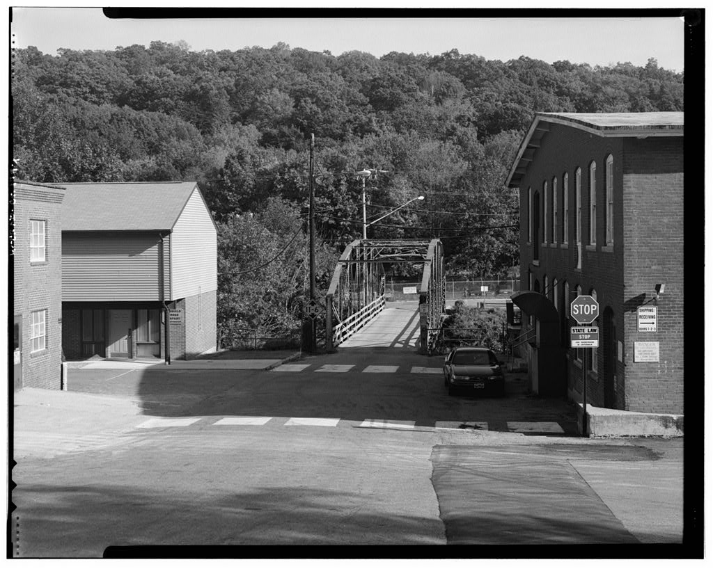
View southeast, general view showing bridge and setting from west end of bridge, river street near intersection with…
View southeast, general view showing bridge and setting from west end of bridge, river street near intersection with main street — September 1998
Image credit & source
Rob Moore / Historic American Engineering Record, Library of Congress
No known restrictions on images made by the U.S. Government; images copied from other sources may be restricted. https://www.loc.gov/rr/print/res/114_habs.html
Original source · Reuse termsSeptember 1998
View north, general view showing bridge and setting, from river street, east side of river
View north, general view showing bridge and setting, from river street, east side of river — September 1998
Image credit & source
Rob Moore / Historic American Engineering Record, Library of Congress
No known restrictions on images made by the U.S. Government; images copied from other sources may be restricted. https://www.loc.gov/rr/print/res/114_habs.html
Original source · Reuse termsSeptember 1998
View northwest, showing east end of bridge
View northwest, showing east end of bridge — September 1998
Image credit & source
Rob Moore / Historic American Engineering Record, Library of Congress
No known restrictions on images made by the U.S. Government; images copied from other sources may be restricted. https://www.loc.gov/rr/print/res/114_habs.html
Original source · Reuse termsSeptember 1998
View southeast, showing west end of bridge
View southeast, showing west end of bridge — September 1998
Image credit & source
Rob Moore / Historic American Engineering Record, Library of Congress
No known restrictions on images made by the U.S. Government; images copied from other sources may be restricted. https://www.loc.gov/rr/print/res/114_habs.html
Original source · Reuse termsSeptember 1998
View northeast, showing south elevation of bridge
View northeast, showing south elevation of bridge — September 1998
Image credit & source
Rob Moore / Historic American Engineering Record, Library of Congress
No known restrictions on images made by the U.S. Government; images copied from other sources may be restricted. https://www.loc.gov/rr/print/res/114_habs.html
Original source · Reuse termsSeptember 1998
View southwest, showing north elevation of bridge
View southwest, showing north elevation of bridge — September 1998
Image credit & source
Rob Moore / Historic American Engineering Record, Library of Congress
No known restrictions on images made by the U.S. Government; images copied from other sources may be restricted. https://www.loc.gov/rr/print/res/114_habs.html
Original source · Reuse termsSeptember 1998
View north, showing underside of bridge, detail of floor beam and stringers
View north, showing underside of bridge, detail of floor beam and stringers — September 1998
Image credit & source
Rob Moore / Historic American Engineering Record, Library of Congress
No known restrictions on images made by the U.S. Government; images copied from other sources may be restricted. https://www.loc.gov/rr/print/res/114_habs.html
Original source · Reuse termsSeptember 1998
View east, showing portal joint from inside, northeast corner
View east, showing portal joint from inside, northeast corner — September 1998
Image credit & source
Rob Moore / Historic American Engineering Record, Library of Congress
No known restrictions on images made by the U.S. Government; images copied from other sources may be restricted. https://www.loc.gov/rr/print/res/114_habs.html
Original source · Reuse termsSeptember 1998
View north, showing portal joint from outside, southeast corner
View north, showing portal joint from outside, southeast corner — September 1998
Image credit & source
Rob Moore / Historic American Engineering Record, Library of Congress
No known restrictions on images made by the U.S. Government; images copied from other sources may be restricted. https://www.loc.gov/rr/print/res/114_habs.html
Original source · Reuse termsSeptember 1998
View west, showing typical lower joint, from inside
View west, showing typical lower joint, from inside — September 1998
Image credit & source
Rob Moore / Historic American Engineering Record, Library of Congress
No known restrictions on images made by the U.S. Government; images copied from other sources may be restricted. https://www.loc.gov/rr/print/res/114_habs.html
Original source · Reuse termsSeptember 1998
View east, lower joint, with hanger for floor beam, and end-panel diagonal stiffner
View east, lower joint, with hanger for floor beam, and end-panel diagonal stiffner — September 1998
Image credit & source
Rob Moore / Historic American Engineering Record, Library of Congress
No known restrictions on images made by the U.S. Government; images copied from other sources may be restricted. https://www.loc.gov/rr/print/res/114_habs.html
Original source · Reuse termsSeptember 1998
View north, showing southwest bridge bearing and west abutment
View north, showing southwest bridge bearing and west abutment — September 1998
Image credit & source
Rob Moore / Historic American Engineering Record, Library of Congress
No known restrictions on images made by the U.S. Government; images copied from other sources may be restricted. https://www.loc.gov/rr/print/res/114_habs.html
Original source · Reuse termsTHE STORY BEHIND THE PHOTOGRAPHS
People, places, and change.
A road into the mill village
River Street Bridge crossed the Moosup River beside the former Cranska thread mill. The federal survey explains its practical role: River Street connected Main Street, the principal route through Moosup, with a residential neighborhood on the opposite bank. It was therefore part of the daily geography linking industry, homes and the village’s streets. The bridge was constructed in 1886 after a flood destroyed crossings in Plainfield and other eastern Connecticut communities. Its history begins with a local need for a dependable route, even though its surviving form also represents a much wider industry in prefabricated iron bridges. [1]
Why the ironwork has that shape
The Berlin Iron Bridge Company supplied a wrought-iron lenticular through truss. Its curved upper and lower lines give it a lens-like profile that is easy to recognize in the photographs. The 1998 report describes a seven-panel span approximately 105 feet long, with pinned connections and original fieldstone abutments. Close views show how individual members, pins and floor supports formed a complete crossing. The gallery can be read from the broad river setting toward these smaller details. Replacement decking and repairs are part of the photographed structure’s accumulated history, rather than evidence that it remained unchanged from 1886. [1]
Other places on the historical landscape
Earlier HABS photographs extend the collection beyond the bridge to Plainfield’s Main Street houses, the Cleveland House, the Old Academy and the First Congregational Church. The Cleveland House is cataloged as dating approximately to 1800. The church’s survey identifies an 1816 building associated with architect Ithiel Town. These places predate much of the archive’s main period, but their later photographic documentation shows how older institutions and houses remained part of the town’s built setting. The photographs should be compared as records of different locations and dates, not assembled into an invented continuous walking route. [2] [3] [4] [5]
Recording a crossing before replacement
Rob Moore photographed the bridge in September 1998 as part of documentation associated with a replacement project. At that time the proposed treatment was dismantling and storage for possible reuse; the report records a plan, not proof of every later outcome. Its photographs preserve the truss in its riverside setting and supply clear directional captions for structural details. Read beside the older architectural images, they show two kinds of preservation record: familiar civic and domestic buildings, and an ordinary piece of infrastructure whose importance became clearer as change approached. [1]
Sources & further reading (6)
- Library of Congress: River Street Bridge, River Street, spanning Moosup River, Plainfield, Windham County, CT
- Library of Congress: Cleveland House, Bradford Hill, Plainfield, Windham County, CT
- Library of Congress: Main Street (Houses), Plainfield, Windham County, CT
- Library of Congress: First Congregational Church, Plainfield, Windham County, CT
- Library of Congress: Old Academy, Plainfield, Windham County, CT
- Connecticut State Library: CT Towns & Counties
Keep the sources close.
Download this collection’s notes, timeline and image credits. Photographs link to their original archives and require an internet connection.
Building dates and photograph dates are recorded separately. Later photographs are identified in their captions; unknown exposure dates remain unknown. Follow each image’s credit and reuse terms.