
New London COUNTY · Waterpower and industrial engineering
Greeneville: The Dam and Canal That Powered a Neighborhood
Thirteen photographs from 1994–1995 trace the dam, headgates, canal, spillway, and drain gate behind Greeneville’s industrial development.
Historical focus · 1828–1996; emphasis 1850–1996
LOOK CLOSER · OPEN ANY IMAGE
The story in photographs
June 1994
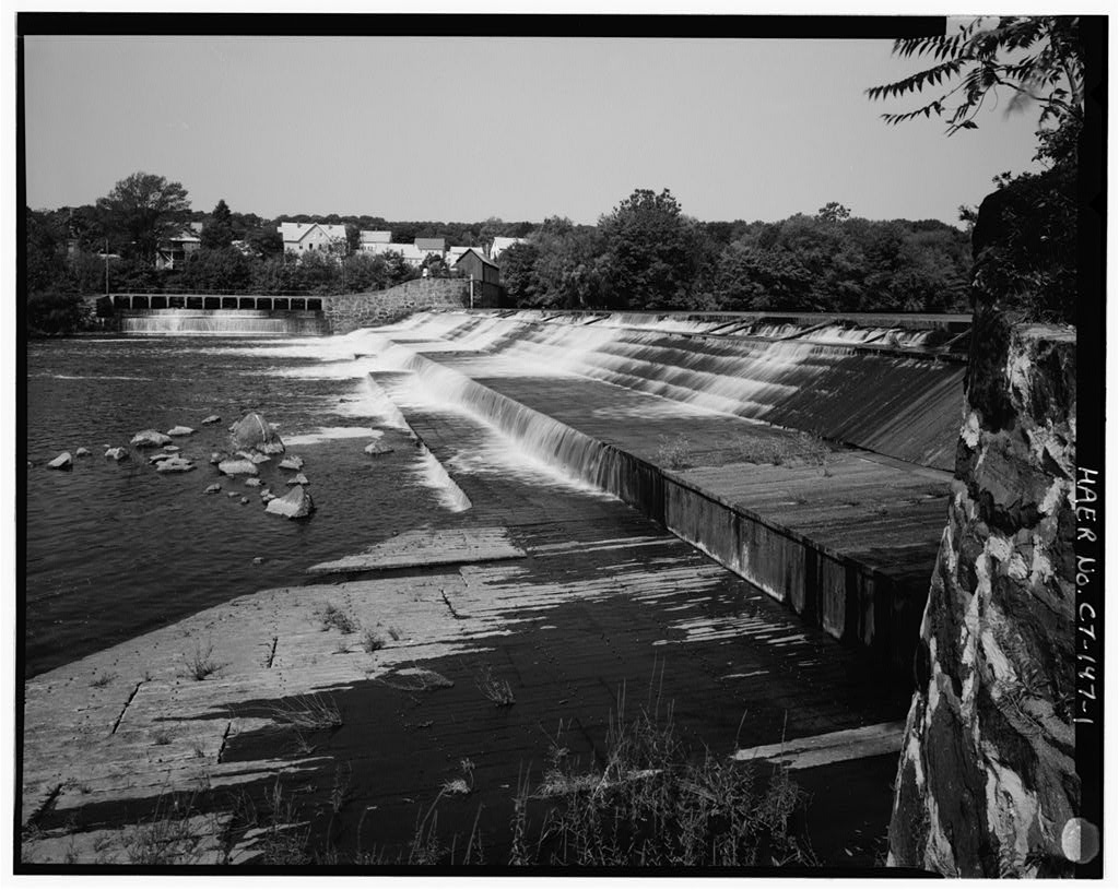
View west, general view of dam, with canal spillway, west abutment, and gatehouse in distance
View west, general view of dam, with canal spillway, west abutment, and gatehouse in distance — Norwich Water Power Company, West bank of Shetucket River beginning opposite Second Street & extending .8 mile northward, Greenville section, Norwich, New London County, CT
Image credit & source
Wayne Fleming; Library of Congress, Prints and Photographs Division, HABS/HAER.
No known restrictions on images made by the U.S. Government; images copied from other sources may be restricted.
Original source · Reuse termsJune 1994
View south, general view showing canal, canal spillway on left, drain gate gatehouse in distance
View south, general view showing canal, canal spillway on left, drain gate gatehouse in distance — Norwich Water Power Company, West bank of Shetucket River beginning opposite Second Street & extending .8 mile northward, Greenville section, Norwich, New London County, CT
Image credit & source
Wayne Fleming; Library of Congress, Prints and Photographs Division, HABS/HAER.
No known restrictions on images made by the U.S. Government; images copied from other sources may be restricted.
Original source · Reuse termsJune 1994
View north, general view showing canal, drain gate gatehouse on right, headgates and gatehouse in distance
View north, general view showing canal, drain gate gatehouse on right, headgates and gatehouse in distance — Norwich Water Power Company, West bank of Shetucket River beginning opposite Second Street & extending .8 mile northward, Greenville section, Norwich, New London County, CT
Image credit & source
Wayne Fleming; Library of Congress, Prints and Photographs Division, HABS/HAER.
No known restrictions on images made by the U.S. Government; images copied from other sources may be restricted.
Original source · Reuse termsJune 1994
View northeast, general view of dam, with canal spillway and gatehouse visible on left
View northeast, general view of dam, with canal spillway and gatehouse visible on left — Norwich Water Power Company, Dam, West bank of Shetucket River opposite Fourteenth Street, Greenville section, Norwich, New London County, CT
Image credit & source
Wayne Fleming; Library of Congress, Prints and Photographs Division, HABS/HAER.
No known restrictions on images made by the U.S. Government; images copied from other sources may be restricted.
Original source · Reuse termsJune 1994
View northwest, detail of stone cap and flashboards at top of dam
View northwest, detail of stone cap and flashboards at top of dam — Norwich Water Power Company, Dam, West bank of Shetucket River opposite Fourteenth Street, Greenville section, Norwich, New London County, CT
Image credit & source
Wayne Fleming; Library of Congress, Prints and Photographs Division, HABS/HAER.
No known restrictions on images made by the U.S. Government; images copied from other sources may be restricted.
Original source · Reuse termsDecember 1995
View northeast, west end of dam during construction of fishway, December 1995, showing removal of planking
View northeast, west end of dam during construction of fishway, December 1995, showing removal of planking — Norwich Water Power Company, Dam, West bank of Shetucket River opposite Fourteenth Street, Greenville section, Norwich, New London County, CT
Image credit & source
Wayne Fleming; Library of Congress, Prints and Photographs Division, HABS/HAER.
No known restrictions on images made by the U.S. Government; images copied from other sources may be restricted.
Original source · Reuse termsDecember 1995
Section view east, west end of dam, December 1995, showing 1915 cribbing; 1882 masonry on left
Section view east, west end of dam, December 1995, showing 1915 cribbing; 1882 masonry on left — Norwich Water Power Company, Dam, West bank of Shetucket River opposite Fourteenth Street, Greenville section, Norwich, New London County, CT
Image credit & source
Wayne Fleming; Library of Congress, Prints and Photographs Division, HABS/HAER.
No known restrictions on images made by the U.S. Government; images copied from other sources may be restricted.
Original source · Reuse termsDecember 1995
View north during construction, December 1995, face of original 1882 masonry dam with capstones
View north during construction, December 1995, face of original 1882 masonry dam with capstones — Norwich Water Power Company, Dam, West bank of Shetucket River opposite Fourteenth Street, Greenville section, Norwich, New London County, CT
Image credit & source
Wayne Fleming; Library of Congress, Prints and Photographs Division, HABS/HAER.
No known restrictions on images made by the U.S. Government; images copied from other sources may be restricted.
Original source · Reuse termsJune 1994
View north, general view showing south wall of bulkhead and archways for water passages; gatehouse
View north, general view showing south wall of bulkhead and archways for water passages; gatehouse — Norwich Water Power Company, Headgates, West bank of Shetucket River opposite Fourteenth Street, Greenville section, Norwich, New London County, CT
Image credit & source
Wayne Fleming; Library of Congress, Prints and Photographs Division, HABS/HAER.
No known restrictions on images made by the U.S. Government; images copied from other sources may be restricted.
Original source · Reuse termsJune 1994
View northwest, interior of gatehouse showing row of gate operating mechanisms; height of stems indicates foreground…
View northwest, interior of gatehouse showing row of gate operating mechanisms; height of stems indicates foreground gate is open — Norwich Water Power Company, Headgates, West bank of Shetucket River opposite Fourteenth Street, Greenville section, Norwich, New London County, CT
Image credit & source
Wayne Fleming; Library of Congress, Prints and Photographs Division, HABS/HAER.
No known restrictions on images made by the U.S. Government; images copied from other sources may be restricted.
Original source · Reuse termsJune 1994
View northwest, detail of operating mechanism, gate closed
View northwest, detail of operating mechanism, gate closed — Norwich Water Power Company, Headgates, West bank of Shetucket River opposite Fourteenth Street, Greenville section, Norwich, New London County, CT
Image credit & source
Wayne Fleming; Library of Congress, Prints and Photographs Division, HABS/HAER.
No known restrictions on images made by the U.S. Government; images copied from other sources may be restricted.
Original source · Reuse termsJune 1994
View north, showing bridge across spillway, two levels of aprons; headgates in background
View north, showing bridge across spillway, two levels of aprons; headgates in background — Norwich Water Power Company, Canal Spillway, West bank of Shetucket River between Thirteenth & Fourteenth Streets, Greenville section, Norwich, New London County, CT
Image credit & source
Wayne Fleming; Library of Congress, Prints and Photographs Division, HABS/HAER.
No known restrictions on images made by the U.S. Government; images copied from other sources may be restricted.
Original source · Reuse termsTHE STORY BEHIND THE PHOTOGRAPHS
People, places, and change.
Selling waterpower in Greeneville
The Norwich Water Power Company incorporated in 1828 and developed a dam and canal the following year. Its enterprise helped establish Greeneville as an industrial district along the Shetucket River. Rather than operating only one factory, the company supplied a setting in which multiple manufacturers could use waterpower. The canal, mill sites, river, and transportation routes formed a connected landscape. By the middle of the nineteenth century, textile and other industrial activities made that arrangement part of Norwich’s wider manufacturing economy. The district’s later history depended on repeated investment in the underlying waterworks. [2]
Rebuilding the river works
The system changed substantially in 1882 under engineer Hiram Cook. New headgates and major dam work reorganized the control of water entering the canal. Flood damage in 1886 prompted further repairs, and the timber portion of the dam was rebuilt again in 1915. The surviving structure therefore contained work from different campaigns rather than a single original construction. Federal photographs made during work in December 1995 exposed parts of that layered fabric. Their captions identify masonry and timber features that are difficult to understand from an ordinary view across the river. [2] [5] [6]
Gates, spillways, and electrical generation
The smaller waterworks are essential to the story. Six arched headgate openings controlled admission to the canal; spillway and drain structures handled water at other points in the system. The canal supplied a series of mill sites, while later electrical generation changed the use of the available power. A municipal hydroelectric installation opened in 1926, followed by another plant in 1966. These developments show continuity in the exploitation of the river even as machinery and customers changed. The photographs join the impressive dam to the less conspicuous controls that made the larger arrangement workable. [2] [8] [11] [14]
An engineering landscape recorded in the 1990s
Wayne Fleming photographed the waterworks in June 1994 and returned for additional dam views in December 1995. The resulting records document broad settings and individual components, including the canal, dam face, headgate mechanisms, spillway bridge, and drain-gate shelter. They preserve evidence of nineteenth- and twentieth-century construction during a period of new work associated with the river. The images are dated records of the system as it then existed. Read alongside the historical reports, they help visitors trace how a neighborhood’s industrial history can remain visible in waterways and structures after many original manufacturing uses have disappeared. [3] [6] [9] [12] [15]
Sources & further reading (15)
- Norwich Water Power Company — Library of Congress survey record
- Norwich Water Power Company — historical and descriptive report
- Norwich Water Power Company — photograph index and photographer credits
- Greeneville Dam — Library of Congress survey record
- Greeneville Dam — historical and descriptive report
- Greeneville Dam — photograph index and photographer credits
- Canal Headgates — Library of Congress survey record
- Canal Headgates — historical and descriptive report
- Canal Headgates — photograph index and photographer credits
- Canal Spillway — Library of Congress survey record
- Canal Spillway — historical and descriptive report
- Canal Spillway — photograph index and photographer credits
- Canal Drain Gate — Library of Congress survey record
- Canal Drain Gate — historical and descriptive report
- Canal Drain Gate — photograph index and photographer credits
Keep the sources close.
Download this collection’s notes, timeline and image credits. Photographs link to their original archives and require an internet connection.
Building dates and photograph dates are recorded separately. Later photographs are identified in their captions; unknown exposure dates remain unknown. Follow each image’s credit and reuse terms.