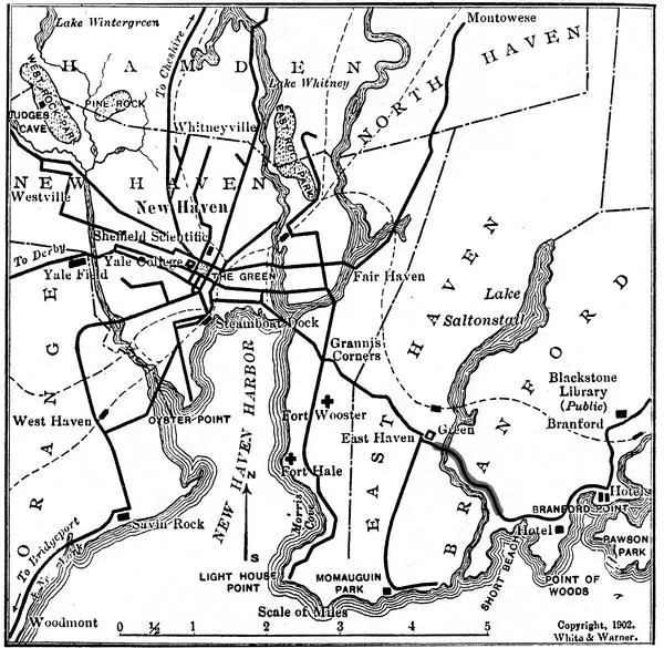
A 1902 map links New Haven with West Haven, Savin Rock, Woodmont and neighboring communities.
Evidence, credit & reuse: Public domain in the United States according to Commons PD-US-expired; base map visibly bears a 1902 copyright imprint. The source states that later shading identifies the section now owned by the Shore Line Trolley Museum. Do not label that shading as an original 1902 feature. Only 600 pixels wide: useful as a local overview, not detailed zoom. Resized and WebP compressed only; no historical content added, retouched or removed.
Source: White & Warner (copyright imprint on map); later annotator unidentified; Shore Line Trolley Museum, reproduced through Wikimedia Commons
Searchable text & research notes
Included OCR or searchable notes appear below and in the download. Use your browser’s Find command to search this page. OCR errors and historical language are retained.
Read the included text
A 1902 map links New Haven with West Haven, Savin Rock, Woodmont and neighboring communities. Follow the printed branches toward Savin Rock and Woodmont on the west side of the harbor, or toward East Haven and Branford on the east side.
Cite this item
Silent Grounds Collective, New Haven & West Haven Trolleys, SGC-TR-019, TR-001, “New Haven and neighboring trolley lines, 1902.” Source: White & Warner (copyright imprint on map); later annotator unidentified; Shore Line Trolley Museum, reproduced through Wikimedia Commons. https://commons.wikimedia.org/wiki/File:New_Haven_trolleys_1902.jpg. Research edition, accessed 2026-09-08.