
Tolland COUNTY · Railways, roads & rivers
Mansfield: a farm-road bridge at the turn of the century
A complete photographic survey of Mount Hope Road Bridge reveals how a small rural crossing connects local travel with Connecticut’s bridge-building industry.
Historical focus · 1900–1994
LOOK CLOSER · OPEN ANY IMAGE
The story in photographs
June 1994
View east, general view of bridge within setting
View east, general view of bridge within setting — June 1994
Image credit & source
Wayne Fleming / Historic American Engineering Record, Library of Congress
No known restrictions on images made by the U.S. Government; images copied from other sources may be restricted. https://www.loc.gov/rr/print/res/114_habs.html
Original source · Reuse termsJune 1994
View north, south elevation
View north, south elevation — June 1994
Image credit & source
Wayne Fleming / Historic American Engineering Record, Library of Congress
No known restrictions on images made by the U.S. Government; images copied from other sources may be restricted. https://www.loc.gov/rr/print/res/114_habs.html
Original source · Reuse termsJune 1994
View south, north elevation
View south, north elevation — June 1994
Image credit & source
Wayne Fleming / Historic American Engineering Record, Library of Congress
No known restrictions on images made by the U.S. Government; images copied from other sources may be restricted. https://www.loc.gov/rr/print/res/114_habs.html
Original source · Reuse termsJune 1994
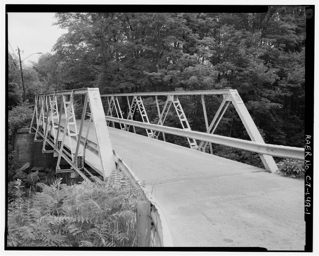
View west, traffic level from east end
View west, traffic level from east end — June 1994
Image credit & source
Wayne Fleming / Historic American Engineering Record, Library of Congress
No known restrictions on images made by the U.S. Government; images copied from other sources may be restricted. https://www.loc.gov/rr/print/res/114_habs.html
Original source · Reuse termsJune 1994
View east, substructure
View east, substructure — June 1994
Image credit & source
Wayne Fleming / Historic American Engineering Record, Library of Congress
No known restrictions on images made by the U.S. Government; images copied from other sources may be restricted. https://www.loc.gov/rr/print/res/114_habs.html
Original source · Reuse termsJune 1994
View northeast, detail of northeast portal joint
View northeast, detail of northeast portal joint — June 1994
Image credit & source
Wayne Fleming / Historic American Engineering Record, Library of Congress
No known restrictions on images made by the U.S. Government; images copied from other sources may be restricted. https://www.loc.gov/rr/print/res/114_habs.html
Original source · Reuse termsJune 1994
View northeast, detail of typical upper joint
View northeast, detail of typical upper joint — June 1994
Image credit & source
Wayne Fleming / Historic American Engineering Record, Library of Congress
No known restrictions on images made by the U.S. Government; images copied from other sources may be restricted. https://www.loc.gov/rr/print/res/114_habs.html
Original source · Reuse termsJune 1994
View east, detail of typical lower joint
View east, detail of typical lower joint — June 1994
Image credit & source
Wayne Fleming / Historic American Engineering Record, Library of Congress
No known restrictions on images made by the U.S. Government; images copied from other sources may be restricted. https://www.loc.gov/rr/print/res/114_habs.html
Original source · Reuse termsJune 1994
View north, east abutment
View north, east abutment — June 1994
Image credit & source
Wayne Fleming / Historic American Engineering Record, Library of Congress
No known restrictions on images made by the U.S. Government; images copied from other sources may be restricted. https://www.loc.gov/rr/print/res/114_habs.html
Original source · Reuse termsJune 1994
View east, east abutment
View east, east abutment — June 1994
Image credit & source
Wayne Fleming / Historic American Engineering Record, Library of Congress
No known restrictions on images made by the U.S. Government; images copied from other sources may be restricted. https://www.loc.gov/rr/print/res/114_habs.html
Original source · Reuse termsJune 1994
View southwest, west abutment
View southwest, west abutment — June 1994
Image credit & source
Wayne Fleming / Historic American Engineering Record, Library of Congress
No known restrictions on images made by the U.S. Government; images copied from other sources may be restricted. https://www.loc.gov/rr/print/res/114_habs.html
Original source · Reuse termsJune 1994
View northeast, detail of southwest bridge bearing
View northeast, detail of southwest bridge bearing — June 1994
Image credit & source
Wayne Fleming / Historic American Engineering Record, Library of Congress
No known restrictions on images made by the U.S. Government; images copied from other sources may be restricted. https://www.loc.gov/rr/print/res/114_habs.html
Original source · Reuse termsTHE STORY BEHIND THE PHOTOGRAPHS
People, places, and change.
A crossing for a farming landscape
Mount Hope Road Bridge was erected over the Mount Hope River in Mansfield in 1901. The surrounding country was then largely open farmland, and the narrow, unpaved roads primarily served local farming families while also leading toward Ashford and Chaplin. The steel span replaced a wooden king-post bridge with planked sides. Mansfield paid its fabricator $850, with additional money for local labor and a derrick used during erection. The crossing therefore records a practical town investment in a route that residents already depended upon, rather than the arrival of a completely new road. [1]
An early Berlin Construction Company bridge
The maker’s plaque names the Berlin Construction Company and dates the bridge to 1901. The company had been founded the previous year by former officials of the Berlin Iron Bridge Company after that older concern entered the American Bridge Company. The federal report identifies Mount Hope Road Bridge as the earliest known surviving example of the new firm’s work at the time of research. Its history links an ordinary rural crossing with a major reorganization of the bridge industry. The new company drew on existing experience and connections with local highway officials, including towns that had already bought Berlin bridges. [1]
How to read the steelwork
The approximately seventy-foot span carried a single lane between five-panel Warren trusses. The repeated diagonals form a recognizable triangular pattern, while close photographs show joints, braces, bearings and the lower structure. Steel members and largely riveted fabrication reflect the increasing standardization of bridge design around 1900. Bolts were also used, and the report suggests some were original features that simplified assembly. The relatively light members and narrow roadway belonged to an era when horse-drawn farm traffic shaped local expectations. These are observations about the documented structure, not a modern assessment of its capacity or safety. [1]
A later road surface, an older structure
A new floor system installed in 1970 replaced the earlier wooden decking with steel sheets beneath a paved surface. Changes to the floor and guardrails remind us that a historic bridge could retain its overall form while receiving substantial maintenance. Wayne Fleming’s June 1994 photographs record that accumulated condition. The federal documentation was prepared when replacement was scheduled, preserving both a view of the crossing in its wooded surroundings and a detailed account of individual components. Its captions allow readers to move from the river setting to the maker’s plaque without confusing the 1901 construction date with the date of the photographs. [1]
Keep the sources close.
Download this collection’s notes, timeline and image credits. Photographs link to their original archives and require an internet connection.
Building dates and photograph dates are recorded separately. Later photographs are identified in their captions; unknown exposure dates remain unknown. Follow each image’s credit and reuse terms.